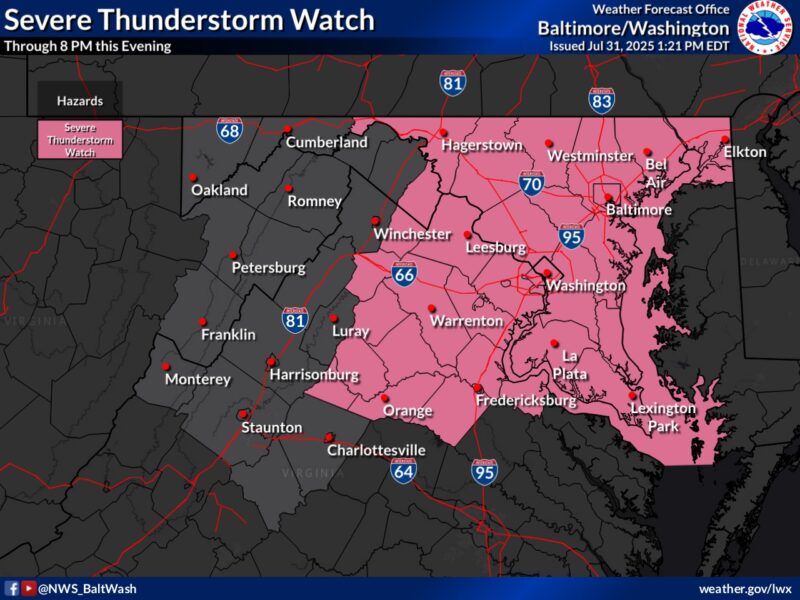
 Severe Thunderstorm Watch remains in effect until 8:00 PM EDT this evening for:
District of Columbia – The entire District is under the watch.
Maryland – Calvert, Charles, St. Mary’s, Anne Arundel, Howard, Montgomery, Prince George’s, Carroll, Frederick, Washington, Cecil, Baltimore County, Baltimore City, and Harford. Along with 22 Counties in Virginia
This Hazardous Weather Outlook is for the Maryland portion of the Chesapeake Bay, Tidal Potomac River, and I-95 corridor through central Maryland, northern Virginia, and District of Columbia.
DAY ONE…This Afternoon and Tonight – A Flood Watch remains in effect through late tonight. Scattered instances of flooding are expected. There is a potential for more widespread flooding with considerable impact. Please have a plan in place to seek higher ground immediately if flash flood
warnings are issued.
A Severe Thunderstorm Watch is in effect for the outlook area until 8 PM. Damaging wind gusts are the primary threat.
*ADDITIONAL DETAILS… – Significant flash flooding is possible. Numerous showers and
thunderstorms will develop and move across the area this afternoon into this evening. Thunderstorms will be capable of producing very heavy rain, with rainfall rates of 1 to 2 inches in 30 minutes.
Widespread rainfall amounts of 1 to 2 inches are expected. Some areas could experience multiple
rounds of thunderstorms, with higher rainfall amounts of 4 to 6 inches possible. This could result in numerous instances of flash flooding. Showers and thunderstorms will begin early this afternoon, and the heaviest rainfall is most likely from 3 PM to 8 PM.
Please visit www.weather.gov/safety/flood for flood safety and preparedness information.

