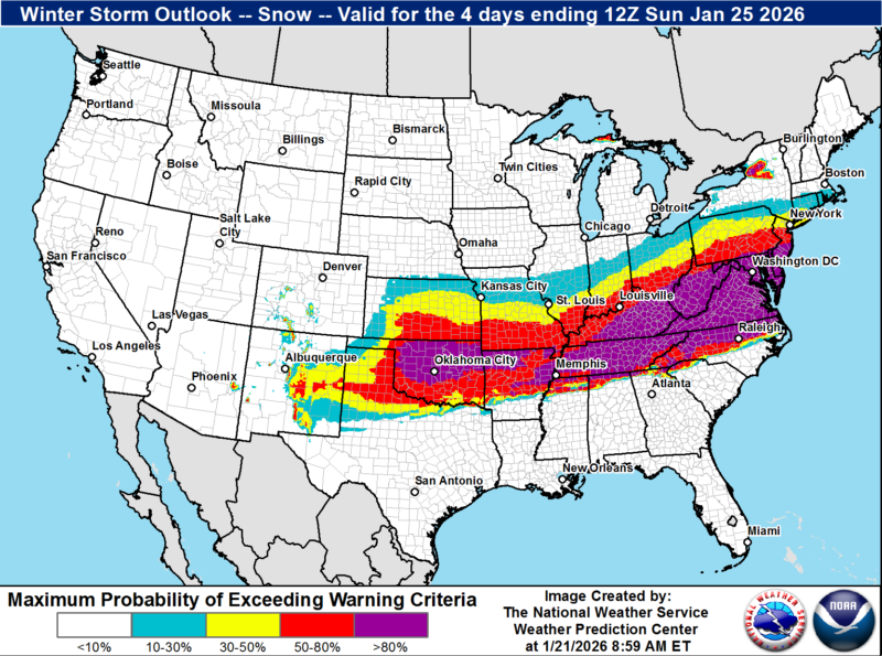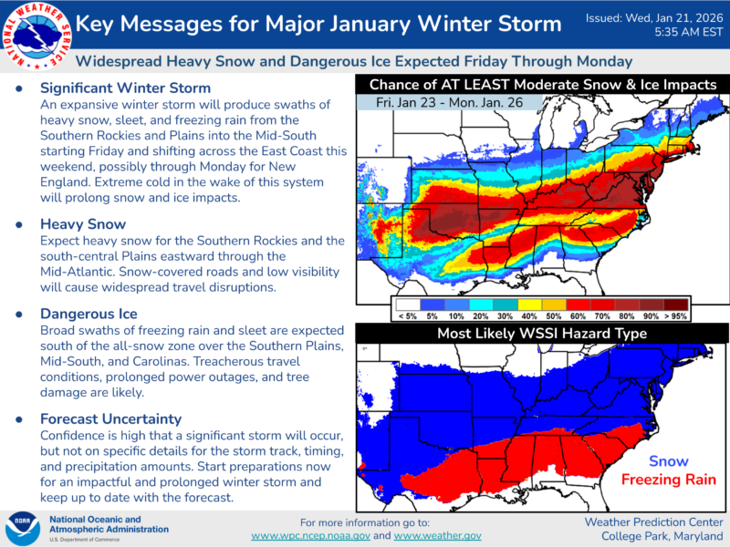
Winter Storm Watch in Effect – WHAT…Heavy snow mixed with sleet and freezing rain possible. There is a high likelihood of at least 5 inches of snow, with over 10 inches possible. Ice accumulation is also possible.
WHERE…DC, and portions of central, northeast, northern, Southern Maryland, and Central and Northern Virginia.
WHEN…From Saturday evening through Monday morning.
IMPACTS…Travel could be very difficult. The hazardous conditions could impact the Monday morning commute.
ADDITIONAL DETAILS…Snow will likely overspread the area Saturday evening, becoming heavy at times late Saturday night with rates of one to two inches per hour possible at times. A mix with sleet or freezing rain is possible Sunday.
Significant icing is possible especially south of Highway 50. Visibility of one-quarter mile or less is possible at times. A prolonged period wind chills in the
teens and single digits is likely beginning Friday evening and lasting through the middle of next week, with sub-zero wind chills possible at times.
Animal Safety Alert Due to Forecasted Weather: Due to forecasted cold temperatures from Saturday, Jan. 17, through Wednesday, Jan. 21, the Department of Public Safety has issued an animal safety alert.
During this period, animal owners and custodians are required to take the following actions to protect pets and livestock:
- Dogs and cats should be brought inside. If a dog or cat is left outside, it must have free access to a solid structure that is heated or set against prevailing winds and allows the animal to maintain its core body temperature.
- Livestock and farm animals should have free access to shelter that allows them to maintain their core body temperature.
- Livestock and farm owners should provide additional food to help animals recover calories lost to cold weather.
- All animals outdoors must be continually monitored for signs of distress.
- All animals must have access to clean, unfrozen water at all times.
For Calvert County Residents – Failure to comply with these safety measures may result in penalties, including fines up to $1,000 or 30 days in jail – To report concerns, citizens may contact the Animal Control Division at 410-535-1600, ext. 2526, Monday through Friday, 8:30 a.m. to 4:30 p.m. After hours, concerns may be reported to the nonemergency line at 410-535-3491.
Maryland Under State of Preparedness – 1/21/2026 Governor Wes Moore declared a State of Preparedness ahead of a potentially hazardous winter weather system that is expected to bring accumulating snow and potential ice to areas of Maryland. The storm will likely affect roads and transportation centers and could cause significant snow accumulation in some parts of the state. Marylanders are cautioned to avoid travel if possible, to follow local forecasts, and to stay prepared for winter storm hazards.
“By declaring a State of Preparedness in Maryland, I am directing the Department of Emergency Management to coordinate the comprehensive preparation of State government ahead of potential impacts related to the incoming weather system,” said Gov. Moore. “The safety and security of our residents is our top priority. Please remain vigilant, listen to authorities, use common sense, and complete emergency preparations as soon as possible.”
A State of Preparedness enhances the State’s ability to respond swiftly and effectively to potential hazards and threats before escalating response, providing an easier path for information sharing and coordination. Multiple State agencies and departments including emergency management, transportation, law enforcement, and public health are coordinating to prepare for the storm.
National Weather Service Up to Date Forecast as of Thursday Morning 1/22/2026:
Snow and Ice Threat: Beginning Saturday afternoon-evening, with peak impacts Saturday night into Sunday morning. Accumulating snow and potential freezing rain and ice will impact the state on Saturday afternoon to evening into Sunday night.
Potential impacts include significant travel delays, closures, and threats to life and property. Plan ahead to minimize impact on you and your family.
“MDEM is monitoring this storm and is coordinating closely with state agencies and local emergency management officials,” said Maryland Department of Emergency Management Secretary Russ Strickland. “Stay tuned to local news stations for the latest updates, sign up for local emergency notifications, and heed any instructions local authorities provide.”
The Maryland National Guard is proactively preparing personnel and specialized vehicles across the state to ensure rapid response capabilities for communities that may require assistance. Personnel and vehicles will be prepositioned in Western Maryland, Central Maryland, and on the Eastern Shore.
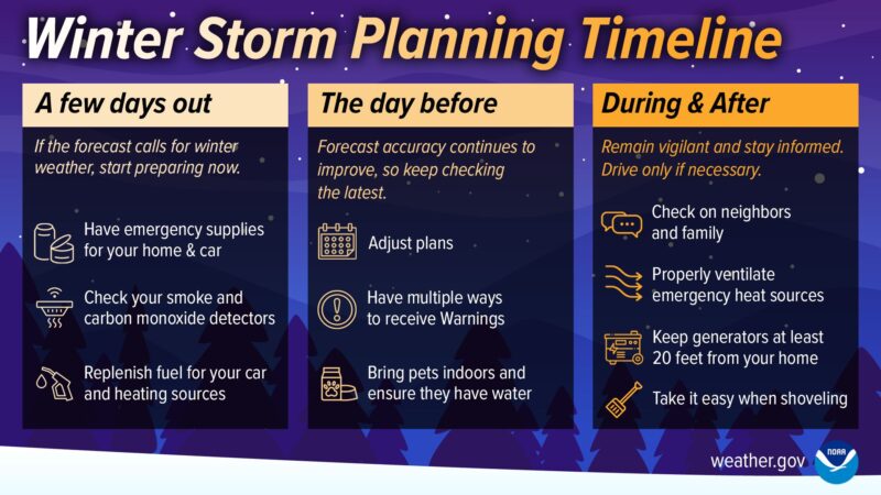
Preparedness Recommendations:
- Stay informed by regularly checking weather updates from official sources and be sure to have a way to access local forecasts and warnings.
- Have an emergency kit ready and a family emergency plan in place.
- Heed all warnings and stay indoors during severe weather.
- Check with local authorities for the latest information about public evacuation shelters.
- Keep devices charged in case of power outages.
- Know who to contact in the case of a power outage. Emergency phone numbers for utility companies can be found at mdem.maryland.gov.
- Follow Maryland Department of Emergency Management and regional National Weather Service social media accounts for localized forecasts.
- Only use generators outdoors and never indoors or in a garage. The generator should be at least 20 feet away from the home and away from windows, doors, and vents.