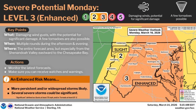
 UPDATE 3/15/2026: The National Weather Service has upgraded our severe potential outlook again, we are now at Level 4 of 5 as Severe Storms are going to be moving into our area along with the cold front.
Morning (7–11 AM): Periods of rain and showers move through the region. This activity will be important because how quickly skies clear afterward will determine how unstable the atmosphere becomes.
Late Morning–Early Afternoon (11 AM–4 PM): A few isolated storms could develop ahead of the main front.
Main Severe Line (3–8 PM): A squall line of strong storms will move through as the cold front arrives. This line could produce widespread damaging winds of 70–80 mph and embedded spin-up tornadoes.
What could still change: If clouds and rain linger longer Monday morning, it could limit how unstable the atmosphere becomes and reduce the severe threat. However, this is still a setup worth taking seriously.
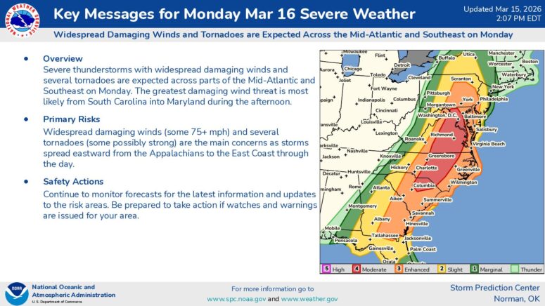
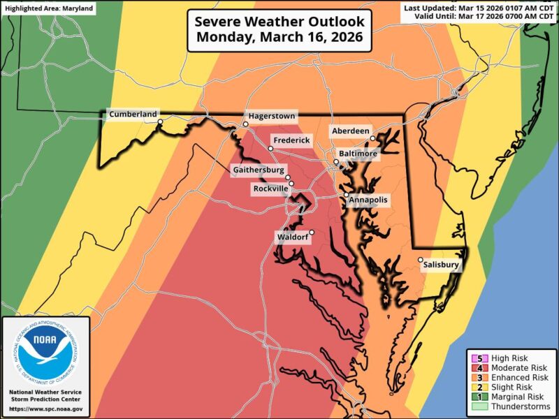
Residents across Southern Maryland, Baltimore and Washington, D.C. should prepare for a potentially dangerous round of severe weather on Monday, March 16, with the threat including damaging winds, large hail and tornadoes. Forecast guidance and National Weather Service products indicate this is a storm system worth taking seriously, especially during the afternoon and evening hours.
The National Weather Service Baltimore/Washington office says a strong cold front will arrive Monday, bringing strong winds and the potential for severe thunderstorms, while forecast products for Lexington Park, Baltimore and Washington all highlight a severe thunderstorm threat with destructive winds and a few tornadoes possible.
The concern is that some storms may develop ahead of the main line and become capable of rotating. If that happens, isolated supercells could produce tornadoes before the main squall line arrives. The most serious threat appears to be from late morning into the evening, depending on location, with damaging straight-line winds potentially becoming the most widespread hazard as the line pushes east. Forecasts for the region also point to the possibility of severe thunderstorms continuing into Monday night before temperatures crash behind the front.
JB Weather has, like many times before, said it best – “In a rare move this far out, the Storm Prediction Center has already placed our region under a Level 3 “Enhanced Risk” of severe weather for Monday. These only get issued a handful of times a year, and hardly 4 days out!
A strong cold front is expected to move through the Mid-Atlantic Monday afternoon. As it does, a line of severe thunderstorms could develop, bringing the potential for damaging wind gusts and fast-developing storms. With a lot of wind energy available in the atmosphere, storms could strengthen quickly or briefly rotate.
I’m normally cautious about highlighting severe threats this far in advance, but this is a setup our region will need to watch closely. The pattern reminds me somewhat of February 24, 2016, when a similar type of front triggered a widespread severe weather outbreak across parts of the Mid-Atlantic.
That said, a lot can and will change between now and Monday. Think of this forecast like a Polaroid photo that will develop over the weekend as we get a clearer picture of the atmosphere. The exact timing, storm types, and primary threats will come into better focus over the next couple of days.”
Follow his updates this weekend and Monday by clicking HERE! Like, comment and share to get his notifications and most recent updates.
According to the National Weather Service point forecast for Southern Maryland, showers and thunderstorms are expected before daybreak Monday, with showers and possible thunderstorms continuing through the morning, then more showers and thunderstorms expected after 2 p.m. Some of those storms could be severe. Monday’s high is forecast near 69 degrees, with south winds around 11 to 18 mph and gusts up to 28 mph. Rainfall totals between a quarter and half an inch are possible, with higher amounts in thunderstorms.
Monday night is expected to remain active, with showers and thunderstorms continuing, and some storms may still be severe. The forecast then calls for temperatures to fall sharply, with a low near 32 degrees as winds shift from southwest to west after midnight. Gusts up to 25 mph are possible Monday night, reinforcing the threat of both storm damage and rapidly changing conditions after the front passes.
What people should know now:
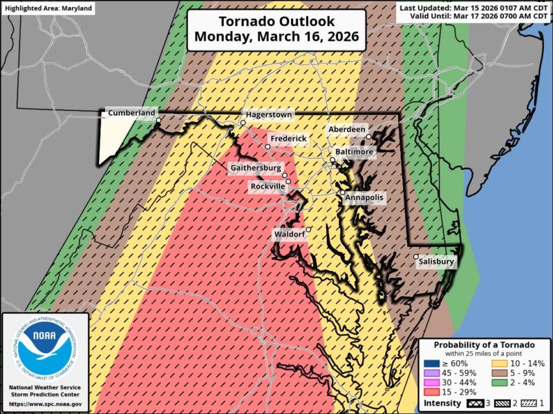
- Tornadoes are possible, including the risk for a few stronger rotating storms if cells remain separate ahead of the main line.
- Damaging straight-line winds may become the more widespread threat as the main line of storms moves through.
- Hail and dangerous lightning will also be possible in severe storms. Severe thunderstorm criteria begins at hail of 1 inch in diameter or wind gusts of 58 mph or higher.
- Conditions may deteriorate quickly, so residents should review their tornado safety plan and have multiple ways to receive warnings.
Watch vs. Warning
A watch means conditions are favorable for severe weather to develop over a broader area and usually for several hours. A warning means dangerous weather is happening or imminent and action should be taken immediately.
Bottom line: Monday’s storm system has the potential to bring widespread severe weather to Maryland, including Southern Maryland, Baltimore and the D.C. region.
This is not a routine spring rain event. People should be prepared for fast-changing conditions, damaging winds, possible tornadoes and additional weather alerts throughout the day and night.