 The Department of Emergency Services wants you to “Know the Difference”
- Tropical Storm Watch: Tropical storm conditions are possible within the specified coastal area within 48 hours.
- Tropical Storm Warning: Tropical storm conditions are expected within 36 hours.
- Hurricane Watch: Hurricane conditions are a threat within 48 hours. Review your hurricane plans, keep informed and be ready to act if a warning is issued.
- Hurricane Warning: Hurricane conditions are expected within 36 hours. Complete your storm preparations and leave the area if directed to do so by authorities.
Hurricane Preparation:
• Get a kit of emergency supplies and prepare a portable kit in case you must evacuate.
• Prepare to secure your property
• Keep all trees and shrubs well-trimmed
• Clean gutters and ditch lines
• If you have a car, fill the gas tank, in case you must evacuate
• Evacuate when officials tell you to. If you are not able to evacuate, stay indoors away from all windows. Take shelter in an interior room with no windows.
• Stay away from downed power lines
• Do not return to your home until county officials say it’s safe
• Check on your neighbors and the elderly
For more information visit: prepare.stmarysmd.com
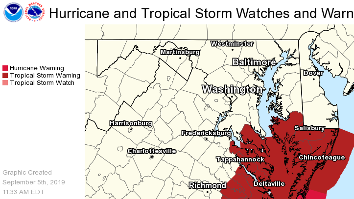
As of Thursday, September 5, 2019 at 11:15 a.m., The National Weather Service placed St. Mary’s County under a Tropical Storm Warning which means tropical storm-force winds are expected somewhere within this area within the next 36 hours and will affect St. Mary’s City with peak wind forecast: 20-30 mph with gusts to 40 mph.
- PLAN: Plan for hazardous wind of equivalent tropical storm force due to possible forecast changes in track, size, or intensity.
- PREPARE: Efforts to protect property should now be underway. Prepare for limited wind damage.
- ACT: Act now to complete preparations before the wind becomes hazardous.
- POTENTIAL IMPACTS: Limited Damage to porches, awnings, carports, sheds, and unanchored mobile homes. Unsecured lightweight objects blown about. Many large tree limbs broken off. A few trees snapped or uprooted, but with greater numbers in places where trees are shallow rooted. Some fences and roadway signs blown over. A few roads impassable from debris, particularly within urban or heavily wooded places. Hazardous driving conditions on bridges and other elevated roadways.
- STORM SURGE: Little to no storm surge flooding through Friday.
- RAINFALL: Predicted Peak rainfall of 1 to 2 inches.
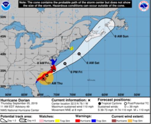
Photo from NHC/NOAA September 5, 2019, 11:00 a.m.