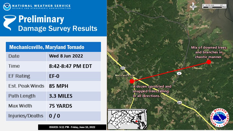
 NWS damage survey for Mechanicsville, MD – Tornado event on June 8, 2022.
Rating: EF-0
Estimated peak wind: 85 mph
Path length /statute/: 3.3 miles
Path width /maximum/: 75 yards
Fatalities: 0
Injuries: 0
Start date: Wednesday, June 8 2022 at 8:42 p.m., start location: 2 SE Mechanicsville in St. Mary’s County, end time at 8:47 p.m., end location: 4 ESE Mechanicsville, St. Mary’s County.
A severe thunderstorm spawned a brief, spin-up tornado Between 8:42 and 8:47 pm edt wednesday evening, june 8, 2022, Near mechanicsville in st. Mary’s county maryland.
The Origins of this severe thunderstorm was the result of cell merger of two separate thunderstorms that approached St. Mary’s county: one crossing eastward over
The Potomac River from near Quantico, Virgina towards Charles County, and the other one crossing northeast over the Potomac from near Colonial Beach, Virginia. The cells merged over central Charles county between La Plata and Dentsville, then proceeded due East towards Northern St. Mary’s county where the tornado occurred.
The severe thunderstorm damaged over two dozen trees and large branches in an approximately three mile radius of the intersection of Maryland Rt.5 (Point Lookout Road and Maryland Rt.235 Three Notch Road.) Of these damage reports were sporadic and isolated in areal extent, but included tree trunk snaps and uproots, with estimated wind speeds between 60 and 70 mph based on tree damage. However, there were two areas of more concentrated damage that helped lead to the likely determination of a tornado in this area of southern Maryland.
The tornado initially touch downed aroud an enclave of residential houses 200 yards southwest of the intersection of route 5 and route 235. Here there was a mix of about a dozen uprooted and trunk snaps of both hardwood and softwood trees. One of the trees fell onto the roof of a residence, causing roof damage; fortunately, with no Injuries despite the resident being inside the home when it fell.
The trees fell to the North, East, Southeast, East, West, and Northwest. Due to the localized but prolific damage in this enclave, wind estimates are up to 85 mph. It is believed that the tornado went right over this enclave of residences due to the random direction of tree falls.
The tornado may have lifted as it moved to the east-northeast. However, tornadic damage was noted about 3 miles further east of initial touchdown along Delabrooke Road, where a chaotic mix of downed trees and branches were observed on both sides, of the 40900 block of Delabrooke Road in deeply forested area.
Residents in this area received the mobile phone alert before the damage occurred, and also reported half-dollar size hail.
A certified NWS skywarn spotter filmed a video from route 235, showing an earthward extension of the cumulus cloud base. Cloud elements appear to be in rotation in this video.
Finally, radar observations from the FAA terminal doppler weather radars at Joint Base Andrews and Reagan National Airport show evidence of rotation at 1400 feet above ground level, well below the base of clouds that evening. Similar rotation at 5000 feet above ground level was observed by the klwx wsr-88d weather radar Located in Sterling, Virginia, albeit several miles south of where The tornado occurred.
The Baltimore/Washington weather forecast office in sterling, Virginia, thanks the St. Mary’s department of emergency services for Their assistance in this survey, along with the residents of St. Mary’s county that were witnesses to this tornado event.
Ef scale: the enhanced fujita scale classifies tornadoes into the
Following categories:
EF0………65 to 85 mph
EF1………86 to 110 mph
EF2………111 to 135 mph
EF3………136 to 165 mph
EF4………166 to 200 mph
EF5………>200 mph