 UPDATE 3/5/2025: This Afternoon and Tonight –
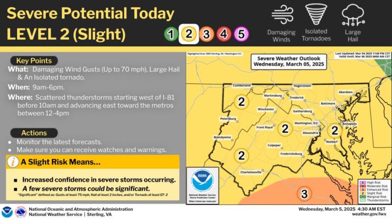
A line of strong to severe thunderstorms will impact the region later this morning and continue into this afternoon.
Severe thunderstorms will be capable of producing damaging wind gusts, large hail and potentially an isolated tornado.
Isolated severe thunderstorms capable of producing damaging wind gusts and hail are possible this afternoon. A tornado or two cannot be ruled out as well. A Severe Thunderstorm Watch is in effect until 6 PM for Southern Maryland and parts of Virginia where the threat is currently highest.
Weather alerts for Wednesday March 5th, through Thursday March 6th, 2025 –
Isolated severe thunderstorms capable of producing damaging wind gusts and hail are possible on Wednesday. A tornado or two cannot be ruled out as well.
Strong winds, including gale conditions, are possible Wednesday afternoon, and again on Thursday behind a strong cold front.
Gale Warnings are in effect for all the waters Wednesday.
Tuesday, March 4th, 2025.
NWS advises of Elevated fire weather conditions are possible through this evening for St. Mary’s and Calvert County
For Charles County – Low humidity and gusty south to southeasterly winds will bring a greater risk of adverse fire behavior and rapid fire spread, mostly from late this morning through late afternoon.
Relative humidity values will drop to 20 to 30 percent, with south to southeast winds of 10 to 15 mph, gusting to 20 to 25 mph.
Firefighters ask to not burn during this time. Calvert, St. Mary’s and Charles County First Responders have responded to over 20 outside, brush or structure fires in the past 9 days.
As of March 4th, 2025, Calvert County is currently having the 10th driest January on record, and 10th driest year to date over the past 131 years.
All St. Mary’s, Calvert and Charles County being listed as having a Moderate Drought, parts of Northern Calvert County are having a Severe Drought (D2)
A Moderate Drought (D1) is the first of four drought categories (D1–D4), according to the U.S. Drought Monitor.

