 As of Monday, 5:00 a.m: A Tropical Storm Watch, and Flash Flood Watch is in effect for Cecil, Baltimore, Kent, Prince Georges, Anne Arundel, Queen Anne’s, Charles, St. Marys, Calvert, Talbot, Caroline, Dorchester, Wicomico, Somerset and Worcester County in Maryland.
First responders urge all citizens to use extra caution during this time due to the strong storms and impacts to effect our region over the next couple of days. Fire and rescue personnel from Prince George’s County, Charles, St. Mary’s and Calvert County responded to over 20 vehicles stuck in high water during strong storms overnight on Wednesday and Thursday, July 6 and 7, 2020. Citizens are urged to turn around, don’t drown!
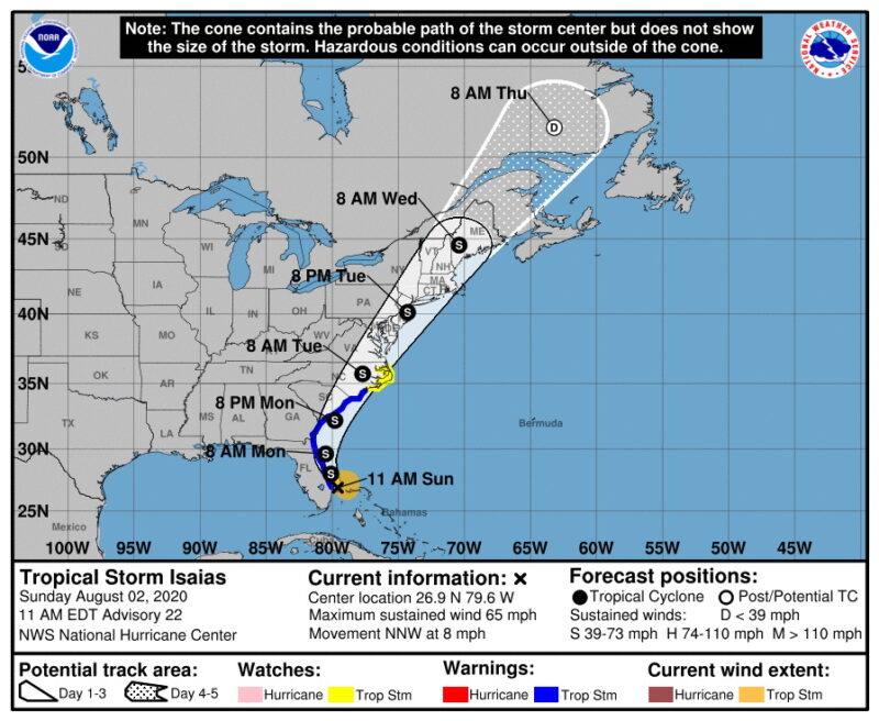
The St. Mary’s County Department of Emergency Services is monitoring Hurricane Isaias as it tracks northwest in the Atlantic Ocean. This system is the ninth named storm of the 2020 season.
Emergency Services wants you to be prepared in advance for the potential impacts of this storm to St. Mary’s County. There is no plan to open shelters at this time, but citizens must be prepared. The following are some things you can do to prepare yourself and your family:
- In case you need to evacuate your home where would you go, hotel, friends or family’s home. With COVID-19 pandemic you need to have a plan.
- If you may need to evacuate, prepare a “go kit” with personal items you cannot do without during an emergency. Include items that can help protect you and others from COVID-19, such as hand sanitizer with at least 60% alcohol, bar or liquid soap, disinfectant wipes (if available) and two cloth face coverings for each person. Face covers should not be used by children under the age of 2. They also should not be used by people having trouble breathing, or who are unconscious, incapacitated, or unable to remove the mask without assistance.
- Know a safe place to shelter and have several ways to receive weather alerts, such as National Weather Service cell phone alerts, (@NWS) Twitter alerts.
- Follow guidance from your local public health or emergency management officials on when and where to shelter.
- Make a plan and prepare a disaster kit for your pets. Find out if your disaster shelter will accept pets. Typically, when shelters accommodate pets, the pets are housed in a separate area from people.
- Follow safety precautions when using transportation to evacuate. If you have to travel away from your community to evacuate, follow safety precautions for travelers to protect yourself and others from COVID-19.
For LIVE alerts from (MEMA) Maryland Emergency Management Agency – Click here: https://mema.maryland.gov/Dashboard_100215v2/index.html
Visit https://www.stmarysmd.com/es/beprepared/ for more preparedness information
https://mema.maryland.gov/Pages/know-your-zone-md.aspx – Even though you may not be able to control a disaster or stop it from happening, you do have control over how you and your family will respond. Protecting yourself and your family in an emergency requires planning. Being prepared will not only help you respond effectively in a dangerous situation, but it can also help you to lessen the impact of a disaster, and sometimes even avoid the danger completely.
Remember, local responders may not be able to reach you immediately, or they may need to focus their efforts elsewhere. Your ability to be self-sufficient may be a matter of survival for both you and your family. Take control of your own safety – it can save your life! Below are several resources that will help you to be prepared for many different types of emergencies that can occur.
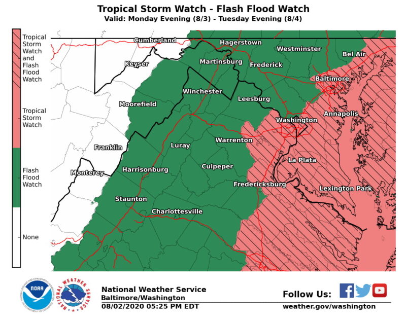
Our current alerts for Anne Arundel, Calvert, Charles, Prince Georges, and St. Mary’s counties include the following:
- Flash Flood Watch in effect until Tuesday, August 4, 2020, at 11:00 p.m.
- Coastal Flood Watch in effect until Wednesday, August 5, 2020, at 12:00 a.m.
- Tropical Storm Watch in effect immediately until further notice, Tropical Storm Warnings are expected to come sometime Monday evening, into Wednesday morning, if TS Isaias stays on current track.
LATEST LOCAL WIND FORECAST: Equivalent Tropical Storm force wind – Peak Wind Forecast: 35-45 mph with gusts to 60 mph – Potential for wind 58 to 73 mph -Window for Tropical Storm force winds: Tuesday morning until Tuesday afternoon
STORM SURGE – LATEST FORECAST: Localized storm surge possible – Peak Storm Surge Inundation: The potential for 1-3 feet above ground somewhere within surge prone areas – Window of concern: early Tuesday morning until early Wednesday morning
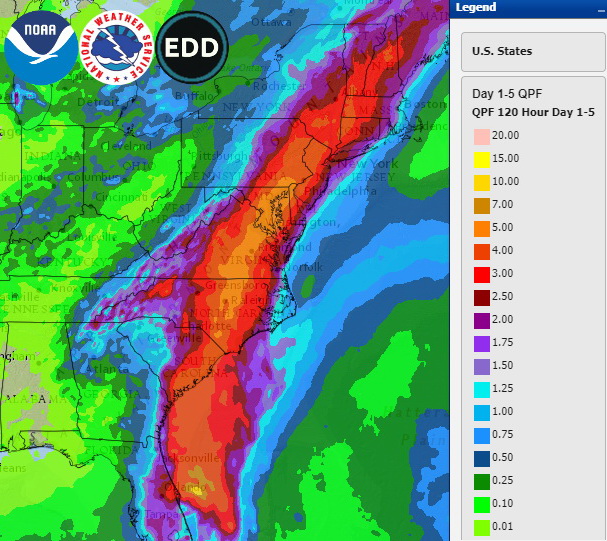
FLOODING RAIN – LATEST LOCAL FORECAST: Flash Flood Watch is in effect – Peak Rainfall Amounts: Additional 3-6 inches, with locally higher amounts
All photos are courtesy of the NOAA, NHC, NWS, MEMA, SMDES, and SMCG.