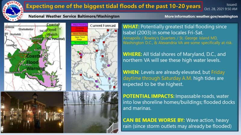
 The National Weather Service says “One of the biggest tidal flood events of the past 10-20 years (possibly since Hurricane Isabel at some locales), is expected Friday & Saturday. Those along tidal shores should get ready for exceptional tidal inundation! Tidal forecasts here: https://water.weather.gov/ahps2/forecasts.php?wfo=lwx
During the last inclement weather that impacted the Charles, Calvert and St. Mary’s County area, First Responders handled over 180 calls of service in a 48 hour timeframe. Including multiple water rescues, a fatal motor vehicle collision caused by a falling tree, and multiple trees onto houses and rescues from flooding conditions.
Citizens are urged to not travel or drive if not needed, do not drive through road closures, around barricades, or through water. TURN AROUND, DON’T DROWN!
A Coastal Hazard Message, Hazardous Weather Outlook, High Wind Warning, and Gale Warning has been issued for parts of Calvert, Charles, St. Mary’s, and Anne Arundel Counties.
COASTAL FLOOD WARNING REMAINS IN EFFECT UNTIL 2:00 p.m., on Saturday, October 30, 2021.
- WHAT…Two to three feet of inundation above ground level expected in low lying areas due to tidal flooding.
- WHERE…Shoreline in St. Marys County.
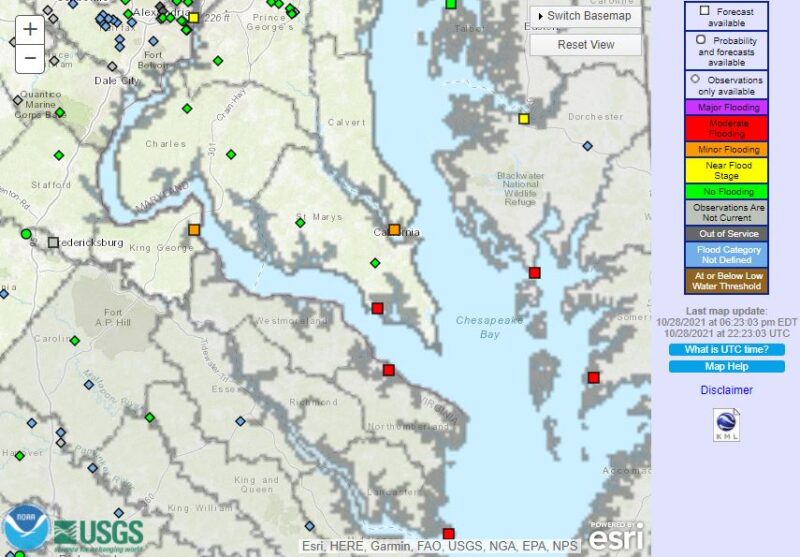
- IMPACTS – At 5.0 feet, significant and widespread inundation is occurring on Saint George Island, and along the lower Tidal Potomac and adjacent tidal tributaries. Numerous roads and structures are affected.
- ADDITIONAL DETAILS…Tides up to 4 feet above normal. The next high tide at Point Lookout is at 7:49 p.m., and 8:19 a.m., The next high tide at Piney Point is at 8:24 p.m., and 9:20 a.m., The next high tide at Coltons Point is at 9:00 p.m., and 9:56 a.m.
- PRECAUTIONARY/PREPAREDNESS ACTIONS… Take the necessary actions to protect flood-prone property. If travel is required, do not drive around barricades or through water of unknown depth. Time of high total tides are approximate to the nearest hour.
St. Mary’s River at Straits Point
MLLW Categories – Minor 3.0 ft, Moderate 3.5 ft, Major 5.0 ft
MHHW Categories – Minor 1.4 ft, Moderate 1.9 ft, Major 3.4 ft
Hazardous Weather Outlook is in effect for Chesapeake Bay from Pooles Island to Sandy Point, North Beach, Chesapeake Bay from North Beach to Drum Point, Tidal Potomac from Key Bridge to Indian Head, Tidal Potomac from Indian Head to Cobb Island, Tidal Potomac from Cobb Island MD to Smith Point, Patuxent River to Broomes Island, Prince Georges, Anne Arundel, Charles, St. Marys, and Calvert Counties
This Hazardous Weather Outlook is for the Maryland portion of the Chesapeake Bay, Tidal Potomac River, and I-95 corridor through central Maryland, northern Virginia, and District of Columbia.
- DAY ONE…This Afternoon and Tonight Coastal Flood Warnings are in effect for many shoreline areas along the Chesapeake Bay and Tidal Potomac River. Moderate tidal flooding is expected.
- DAYS TWO THROUGH SEVEN…Friday through Wednesday – high impact tidal flooding is expected Friday into Saturday. Coastal Flood Warnings are in effect for many shoreline areas along the Chesapeake Bay and Tidal Potomac River from Friday through Saturday morning. Moderate tidal flooding is expected, and major flooding cannot be ruled out in a few locations.
A Storm Warning is in effect Friday for the Maryland Chesapeake Bay from North Beach to Smith Point, including the nearby tributaries as well as the lower Tidal Potomac River from Cobb Island to Smith Point. A Gale Warning is in effect Friday for the rest of the waters. A Gale Warning is in effect for all the waters Friday evening. A High Wind Warning is in effect for St Marys and Calvert Counties and a Wind Advisory is in effect for Harford, southern Baltimore, and Anne Arundel Counties Friday. The strongest winds are expected along the shoreline of the Chesapeake Bay, Patuxent, and Patapsco Rivers.
Locally damaging wind gusts from heavier showers or an isolated thunderstorm are possible Friday afternoon and early evening. An isolated tornado cannot be ruled out across southern Maryland.A Flood Watch is in effect from 10 AM Friday morning through 6 PM for the Washington and Baltimore Metropolitan areas. Elsewhere,
isolated instances of flooding are possible.
- SPOTTER INFORMATION STATEMENT – Spotter activation may be needed Friday. Please send any flood or wind damage reports to the National Weather Service.
High Wind Warning – St. Mary’s and Calvert County. Including the cities of Lexington Park, California, Chesapeake Beach, Huntingtown, Dunkirk, North Beach, Lusby,
and Prince Frederick
- HIGH WIND WARNING IN EFFECT FROM 8:00 a.m., on Thursday October 28, to 6:00 p.m., on Friday October 29, 2021.
- WHAT…East winds 20 to 35 mph with gusts up to 60 mph expected. The strongest winds will be along the immediate shoreline along the Chesapeake Bay and Patuxent River.
- IMPACTS…Damaging winds will blow down trees and power lines. Widespread power outages are expected. Travel will be difficult, especially for high profile vehicles.
- PRECAUTIONARY/PREPAREDNESS ACTIONS – People should avoid being outside in forested areas and around trees and branches. If possible, remain in the lower levels of your home during the windstorm, and avoid windows. Use caution if you must drive.
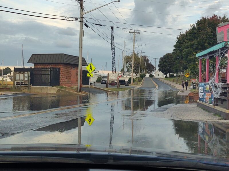
Photo taken by Bob Johnston at approximately 5:30 p.m., on Thursday, October 28, 2021, at the Calvert County Tiki Bar